top of page


CIVIL WORKS
Civil works
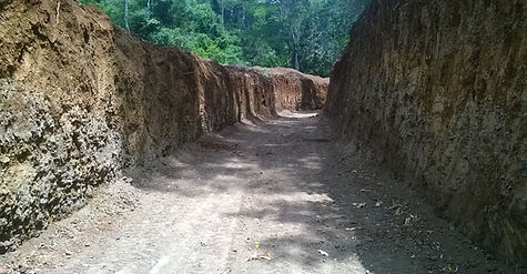
Part of the civil works have been already been completed good level estimated at 45% as been carried
out, including the diverting weir and spillway foundations, banks stabilisation, intake and desilting basin,
420m of complete box canal, full excavation of the remaining 3.4Km canal, earthworks of the power
station location and road. Key remaining civil works include completing the spillway, the canal, the
forebay tank, penstock anchor, the powerhouse and the tail race.


Kleen Energy is aiming for 40% employment of women on site, although this is constrained by thephysical nature of the work..

Hydrological considerations
and site location
The Project lies within an area of moderately high rainfall, with peaks in April and in November and dry
periods between January and February, and June to September below which was compiled using data
dating back to 1975, collected at a weather station 2km east of the Project’s intake.
The river flow is influenced not only by rainfall but also through its being part of a greater drainage
basin commencing with snow on the top of Mount Kenya and springs at the base of the mountain.
According to Kenya National Adaptation Plan: 2015-2030, Government of Kenya, July 2016, Kenya will
become wetter as a result of climate change by 2060, with the level of rainfall during the rainy seasons
to increase. The forecast increase in precipitation ranges between 2% and 11%. Moreover, the region
around Mount Kenya is considered to be at low risk to drought.

Community and environmental considerations
A full Environmental Impact Assessment (“EIA”) report in conformance to IFC Performance Standards
on Environmental and Social Sustainability and the European Investment Bank’s Environmental and
Social Standards, was done covering Environmental and Social Impact Assessment.

bottom of page